
Mekong Region Countries

Mekong River viewed from Wat Roi Phra Putthabat Phu Manorom in Mukdahan
The Mekong Region, also known as Greater Mekong Sub-region or GMS, or Greater Mekong. Located at the South China Peninsula, a trans-national extended economic region in the Mekong River basin, is part of the continental portion of Southeast Asia. Because geographically adjacent to India and China, people in the region were highly influenced by India and China since the very early days. Hence, also called Indochinese peninsula.
Eastern part of the region, Laos, Cambodia and Vietnam used to collectively called Indochina during French Colonial era. Laos is a landlock country, sandwiched between Thailand and Vietnam, neighboring Laos to the north is Yunnan province of China and Cambodia to the south. Neighboring Thailand to the west is Myanmar, Myanmar is located between India and Thailand.
A development program initiated by the Asian Development Bank in 1992, where several economic corridors being established in order to promote economic and social developments of the respective areas. Namely:
-
- The North-South Economic Corridor – NSEC
- The East-West Economic Corridor – EWEC
- The Southern Economic Corridor – SEC
Mekong Region Economic Corridors consist of the following 6 countries:
-
- Laos
- Thailand
- Cambodia
- Vietnam
- Myanmar
- China (Yunnan and Guangxi Provinces)
The program focuses on:
-
- Connectivity through physical infrastructure and the development of economic corridors.
- Market integration and the facilitation of cross-border trade and travel.
- Community of shared social and environmental concerns.

Mekong Region Map (map credits to alchetron)
Mekong Region Connectivity
Transport Corridors
To eliminate connectivity problems, which is among the most crucial, not only obstacles for economic and social developments but also constraint on trade relations among the Mekong Region countries. With Operational priorities of Roads, Railway, Seaports, Riverports, Airports and Urban transport, concept of Transport Sector Strategic Corridors have been adopted as following.
-
- North-south transport corridor:
Kunming – JingHong – Chiang Rai (Luang Namtha – HouayXay) – Phayao – Tak – Nakhon Sawan – Saraburi – Bangkok
NS Extension: from Bangkok, southward to Prachuap Khirikhan, Surat Thani, Songkhla, and Malaysian border provinces of Narathiwat and border town of Hat Yai. This route is complement of the Kunming – Singapore Railway Network - East-west transport corridor:
Mawlamyine – Myawaddy – Tak – Sukhothai – Phisanulok – Khon Kaen – Kalasin – Mukdahan – Savannakhet – Dong Ha - Northern transport corridor:
Nanning – Kunming – Dali – Ruili – Lashio – Mandalay – Kalewa – Kalewa (border town to India) - North-Eastern corridor:
Bangkok – Sarabun – Phetchabun – Luang Prabang – Xam Nua – Thanh Hoa - Eastern transport corridor:
Kunming – Nanning – Lao Cai – Hanoi – Dong Ha – Da Nang – Quy Nhon – Ho Chi Minh city – Ca Mau - Western transport corridor:
Kalay – Bagan – Magway – Nay Pyi Daw – Bago – Mawlamyine - Central transport corridor:
Luang Namtha – Luang Prabang – Vientiane – Khon Kaen – Nakhon Ratchasima – Laem Chabang (sea port) / Vientiane – Pakxan – Savannakhet – Pakxe – Stung Treng – Kratie – Phnom Penh – Sihanoukville - Southern transport corridor:
Dawei – Kanchanaburi – Bangkok – Prachin Buri – Sisophon – Siem Reap – Stung Treng – Pleiku – Quy Nhon / Battambang – Kampong Cham – Phnom Penh – Ho Chi Minh City – Vung Tau - Southern Coastal transport corridor:
Bangkok – Laem Chabang – Rayong – Trat – Khemara Phoumin – Sihanoukville – Kampot – Ca Mau
- North-south transport corridor:
ASEAN Rail Corridor
As global trade faces challenges from tariffs amid renewed rivalry, the Association of Southeast Asian Nations (ASEAN) is turning its attention inward to strengthen regional connectivity.

The Laos-China 414km railway line took five years to construct under China’s trillion-dollar Belt and Road Initiative. (Photo: AFP/STR, Lao National TV)
Experts said expanding intra-ASEAN trade hinges on improving rail links, with collaboration among member states key to unlocking the success of the ASEAN Rail Corridor that was launched last year.
A seamless and reliable regional rail freight service is seen as vital to boosting the bloc’s total trade volume, which is projected to reach US$4.5 trillion by 2030. Read more…
Mekong River
Mekong River flows along many of the Cities in China, Myanmar, Laos, Thailand, Cambodia and Vietnam. Including:
- Xishuangbanna, Guanlei in Yunnan
Guanlei is an important entrepot for China’s trade with Thailand - Golden Triangle (Tachileik / Chiang Saen / Huay Xai)
- Chiang Khong / Huay Xai in Thailand / Laos
The 4th Thai–Lao Friendship Bridge between Chiang Khong in Chiang Rai province and Huay Xay in Bokeo province opened to the public on 11-December-2013. It is a highway bridge links the last section of Asian Highway route 3 – AH3 - Luang Prabang in Laos
An UNESCO World Heritage Site in north central Laos, for its well preserved and unique architectural, its religious and cultural heritage. Very famous for numerous of the Buddhist temples and monasteries. - Nong Khai in Thailand / Vientiane in Laos
Where the 1st Thai–Lao Friendship Bridge built and opened in 1994 - Bueng Kan in Thailand / Bolikhamxay in Laos
The 5th Thai-Lao Friendship Bridge is under construction, scheduled to be opened in 2024
Bueng Kan – Bolikhamxay Bridge *Under construction
- Nakhon Phanom in Thailand / Thakhek in Laos
The 3rd Thai–Lao Friendship Bridge opened for traffic in 2011 across Mekong River here - Mukdahan in Thailand / Savannakhet in Laos
The 2nd Thai–Lao Friendship Bridge completed in 2006 and opened to the public in January 2007
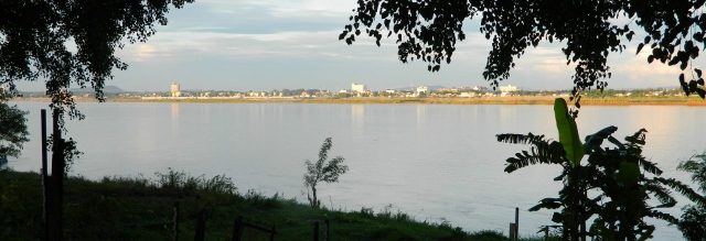
Mukdahan Thailand can be viewed from Savannakhet in Laos across Mekong River
- Pakse, Champassak, Si-phan-don in Laos
Si-phan-don literally means 4,000 island in Lao, is a riverine archipelago in southern Laos. Many of the islands submerge during summer monsoon flooded season - Stung Treng, Kampong Cham, Tonle SAP Lake, Phnom Penh in Cambodia
Tonle SAP Lake connects to Mekong River through 120 km long Tonle SAP river. Is a natural floodplain reservoir which regulates the flow to Mekong Delta during Summer and Winter monsoons - Chau Doc / Tan Chau, Can Tho, Vinh Long, My Tho
The area also known as Mekong Delta, or the River of Nine-dragons in Vietnam - The water enters south China Sea via the multiple tributaries of Mekong Delta
With over 4,000 km in length , for thousands of years Mekong River has been an important gateway for people and goods among many of the townships along the river in the region. Traditional forms of trades in small boats linking communities continue today, however the river is becoming not only one of the essential transport alternative for important link in international trade routes, connecting six Mekong countries to each other. But, also an important tourist destination to many of the townships along the river.
More importantly, from tens of decades ago, for Mekong Region Countries,
-
- Mekong River is also the lifeline of tens of millions of people through fishing and farming
- The largest inland fishery site especially in Tonle SAP fresh water lake, which is also part of the Mekong River ecosystem
- The total land used for growing cereals in Mekong River Delta makes up 47% of Vietnam’s national total
- Mekong River is known as the most productive river system on earth
Mekong River rises as Za Qu in Tibetan Plateau, which is the source of the 3-rivers, namely Yellow river, the Yangtze river, and Mekong river is also one of the 3 Parallel Rivers, that is Nujiang river, Mekong river and Yangtze river.
Mekong River is abbreviated form of Mae-Nam-Khong, meaning Mother-Water-River in Tai (Dai) language. Mekong River is known as Lancang-Jiang or Lancang River in China. Lancang River also called Upper Mekong River, while Mekong River is generally referred to the Lower Mekong River.
Jinghong
Jinghong, or Sipsongpanna is more commonly called by the locals, is one of the three counties of Xishuangbanna Dai Autonomous Prefecture. Jinghong is a county-level city located at the southern part of Lancang Jiang, also known as Upper Mekong River. Bordering Jinghong to the north is Pu’er city and Shan state of Myanmar to the south.
Jinghong port used to be the tourism hub for tourists travelling to Thailand and Laos destinations, especially the Golden Triangle and the heritage town of Laos – Luang Prabang. But the service has been suspended since the Mekong River Massacre happened in 2011, that causes 13 Chinese shippers killed in the heart of Golden Triangle area.
In 2021, opening of Kunming – Vientiane Railway, which is part of the Pan-Asian Railway also known as Kunming – Singapore Rail Link. Jinghong reclaims the crown back as Transportation Hub in Southwestern China of Yunnan. Also the main gateway to Southeast Asian mainland countries.
Golder Triangle
Is a popular tourist destination in northern Thailand, for its specific one-for-3 geographical locations. That is,
Myanmar, Thailand and Laos on the junction of the Ruak river and Mekong river.
- Tachileik in Myanmar, bordering to Thailand’s northmost tip district – Maesai, is an important border checkpoint between Thailand and Myanmar in Golden Triangle region.
- Ban Sop Ruak near Chiang Saen town in Chiang Rai province of Thailand
- Houay Xay, the capital of Laos’ Bokeo Province, Laos
Used to be the Detroit of Opium/Heroin in South-east Asia, the largest exporter of Heroin in the past. Golden Triangle is synonyms of Heroin, was named by a US official in 1971 during a press conference regarding opium trade. Whereas, Khun Sa, is the famous drug lord in Golden Triangle once controlling the drug empire.
With passengers cruise servicing tourists mainly from China between Jinhong, Yunnan and Golden Triangle until the occurrence of Mekong Massacre Incident in year 2011.
Golden Triangle Special Economic Zone
Located just opposite across the Mekong River of Thai village called Ban Sop Ruak near Chiang Saen town, a Special Economic Zone was created in Bokeo Province, Laos in year 2007 by the Kings Romans Group, a Chinese-owned company. With the formulated hope of generating economic development, particularly casino is the main attractions for Chinese investors.
Besides tourism industry, its 300 tons of cargo vessels sailing capability of Mekong River waterway, Golden Triangle is an important riverport, which accommodates goods between Guanlei – Yunnan and Chiang Saen, Thailand today.
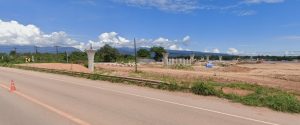
Savannakhet
Officially known as “Kaysone Phomvihane” is the capital of Savannakhet Province, also the 2nd largest city in Laos. Situated south of Vientiane and north of Pakse Opposite of Mekong River is Mukdahan, Thailand. Mekong River had been the main artery of transport since French colonial era, until the Second Thai–Lao Friendship Bridge opened in 2007, which connects Savannakhet to Mukdahan across the river and the border of Laos and Thailand.
Savannakhet is one of the transport hubs in the East–West Economic corridor, which created in order to promote economic development amoung the Mainland Southeast Asian countries, including Myanmar, Thailand, Laos, Cambodia and Vietnam.
The economic corridor spans from Mawlamyine and Myawaddy in Myanmar on the western-most, crossing over Moei River via Thai-Myanmar Friendship Bridge to Mae Sot, Tak, Sukhothai, Khon Kaen, Kalasin and Mukdahan in Thailand. Then, crossing the Mekong River to Savannakhet, and further to the east crossing over the Lao-Vietnamese border, across Quang Tri, Thua Thien–Hue Province and Da Nang as the eastern-most city.
Phnom Penh: The Economic Heart of Cambodia
Phnom Penh is the political, economic, and industrial capital of Cambodia. After decades of recovery from conflict, its economy has been one of the fastest-growing in Asia, driven by several key sectors:
Garment and Footwear Manufacturing: The backbone of the formal economy, employing hundreds of thousands. These factories are major exporters, primarily to the US and EU.
Construction and Real Estate: A boom in high-rise buildings, commercial centers, and satellite cities, largely fueled by foreign direct investment (especially from China).
Services and Tourism: The city is a gateway to Angkor Wat and has developed its own hospitality, food, and retail scene. Banking and finance are growing rapidly.
Trade and Logistics: As the nation’s hub, all major road and river networks converge here. The Phnom Penh Autonomous Port is a critical node.
Lancang / Mekong River
Image source: Wikipedia
Mekong River Delta

Thailand and Mekong River
Chiang Saen in the northern part of Chiang Rai province, along with the Mekong River, forming the boundary with Laos, is an important entrepot for Thailand’s international trade with the upper Mekong River region.

Laos and Mekong River
Laos is the only landlocked country in Mekong Region. Mekong River forms a large part (1,754 kilometers) of the western boundary with Thailand, whereas the mountains of the Annamite Range forms most of the eastern border (2,130 kilometers) with Vietnam.

Angkor, Tonle SAP and Mekong River
Located amid forests and farmland north of Tonlé Sap, Angkor had been the largest pre-industrial city in the world, with an elaborate infrastructure system connecting an urban sprawl of at least 1,000 square kilometres to the well-known temples at its core.

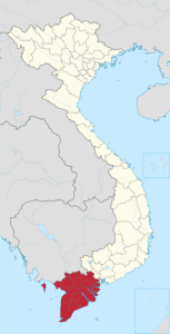
HCMC, Mekong Delta and Mekong River
Ho Chi Minh city (HCMC), former name and also still used by the locals is called Saigon, located immediately to the east of Mekong Delta, is the largest city in Vietnam.